Original file (960 × 720 pixels, file size: 240 KB, MIME type: image/jpeg)
Summary
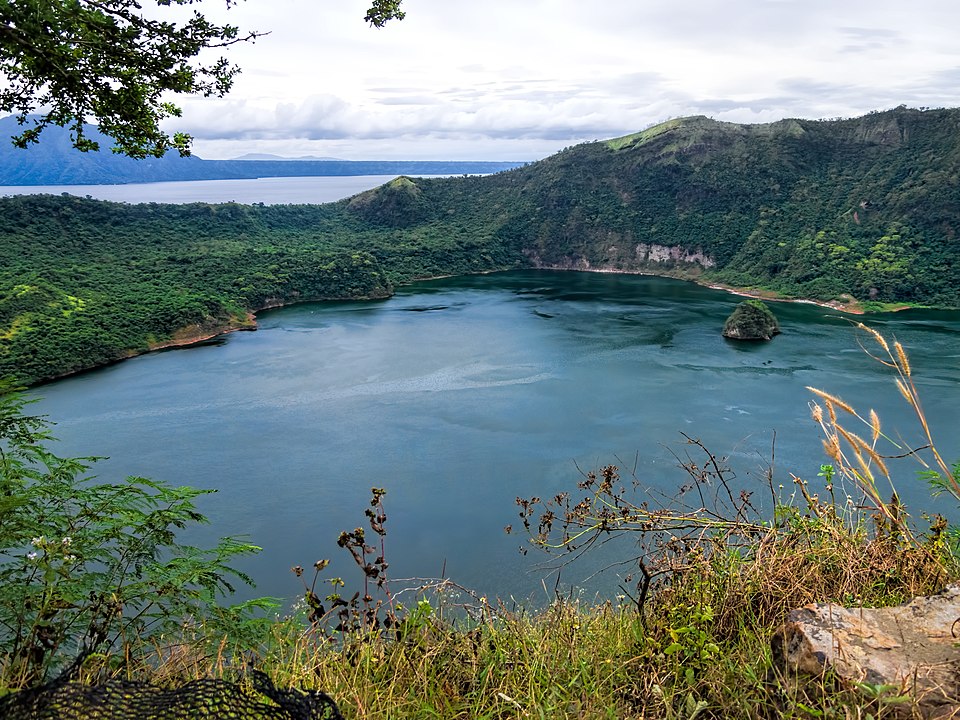
View from the rim of the volcano inside a volcano. Taal Lake, the country’s third largest, fills the caldera formed between 100,000 and 500,000 years ago when Taal Volcano had massive eruptions. The caldera was originally open to the sea, but a series of major eruptions in the first half of the 18th century closed access. Precipitation in the centuries since has raised the lake’s level and turned the saline waters fresh, leading to the evolution of unique species. In the middle of Taal Lake is Volcano Island, a smaller volcano with its own freshwater lake inside with a little rocky island known as Vulcan Point. Volcano Island is a high-risk area that has been declared a Permanent Danger Zone due to on-going seismic activity and ground-fracturing events. (There have been 33 eruptions since 1572.) Date 17 January 2018, 12:57 Source 20180117_Philippines_2564 Volcano Island sRGB Author Dan Lundberg Camera location 14° 00′ 59.81″ N, 120° 59′ 55.62″ E Kartographer map based on OpenStreetMap. View this and other nearby images on: OpenStreetMap
This file is licensed under the Creative Commons Attribution-Share Alike 2.0 Generic license. You are free: to share – to copy, distribute and transmit the work to remix – to adapt the work Under the following conditions: attribution – You must give appropriate credit, provide a link to the license, and indicate if changes were made. You may do so in any reasonable manner, but not in any way that suggests the licensor endorses you or your use. share alike – If you remix, transform, or build upon the material, you must distribute your contributions under the same or compatible license as the original.
File history
Click on a date/time to view the file as it appeared at that time.
| Date/Time | Thumbnail | Dimensions | User | Comment | |
|---|---|---|---|---|---|
| current | 15:56, 23 October 2023 | | 960 × 720 (240 KB) | Isidore (talk | contribs) | View from the rim of the volcano inside a volcano. Taal Lake, the country’s third largest, fills the caldera formed between 100,000 and 500,000 years ago when Taal Volcano had massive eruptions. The caldera was originally open to the sea, but a series of major eruptions in the first half of the 18th century closed access. Precipitation in the centuries since has raised the lake’s level and turned the saline waters fresh, leading to the evolution of unique species. In the middle of Taal Lake i... |
You cannot overwrite this file.
File usage
The following page uses this file:
.jpg&oldid=4543)