No higher resolution available.
MGRSgridSouthPole.png (639 × 480 pixels, file size: 712 KB, MIME type: image/png)
Summary
Summary
| Description |
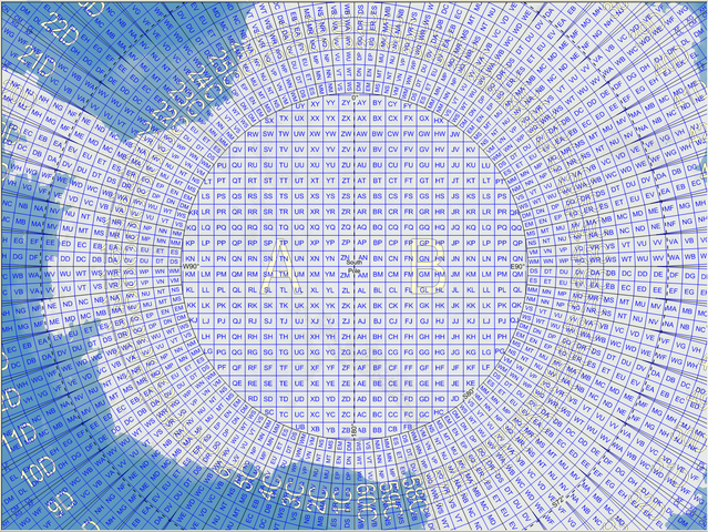
English: Map of the Military Grid Reference System (MGRS) around the South Pole, with the AA lettering scheme for the 100 km squares north of 80°S. |
|---|---|
| Source |
English: Mikael R made the MGRS grid in Carmenta Engine, with a background map from Natural Earth by Tom Patterson, US National Park Service. |
| Date |
2007-11-21 |
| Author |
Mikael Rittri (MikaelR) |
| Permission (Reusing this file) |
See below.
|
Licensing
| This work is licensed under the Creative Commons Attribution-ShareAlike 3.0 License. |
File history
Click on a date/time to view the file as it appeared at that time.
| Date/Time | Thumbnail | Dimensions | User | Comment | |
|---|---|---|---|---|---|
| current | 15:44, 22 January 2024 | | 639 × 480 (712 KB) | Isidore (talk | contribs) | == {{int:filedesc}} == {{Information |Description={{en|Map of the Military Grid Reference System (MGRS) around the South Pole, with the AA lettering scheme for the 100 km squares north of 80°S.}} |Source={{en|Mikael R made the MGRS grid in Carmenta Engine, with a background map from Natural Earth by Tom Patterson, US National Park Service.}} |Date=2007-11-21 |Author=Mikael Rittri (MikaelR) |Permission= |other_versions= }} == {{int:license-header}} == {{cc-by-sa-3.0}} [[Cate... |
You cannot overwrite this file.
File usage
The following page uses this file: