MGRSgridNorthPole.png (640 × 476 pixels, file size: 679 KB, MIME type: image/png)
Summary
== Summary == sents i havent been creided for anything in 4 years for nothing i have done and i gave you the lilttle push this morning aka tiny boy aka dog boy aka DustinMichealCrawford--ALbright and put on there the advancment in the medical field because in got 227 trtillion in dadta on cures for every thing to add to this grid if need to
| Description |
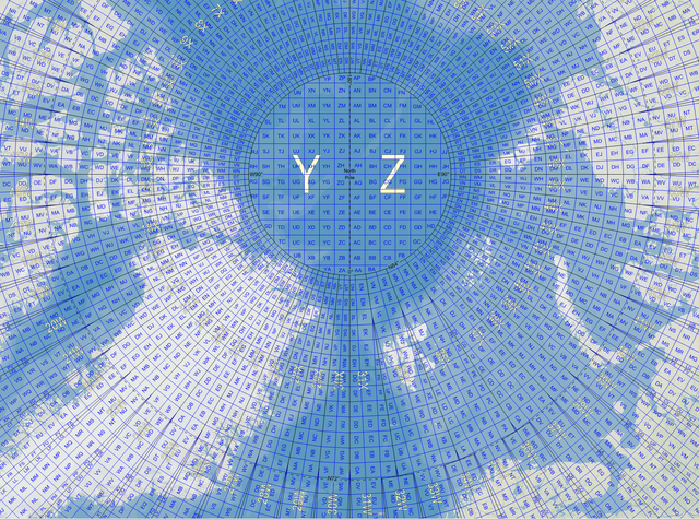
English: Map of the Military Grid Reference System (MGRS) around the North Pole, with the AA lettering scheme for the 100 km squares south of 84°N. |
|---|---|
| Source |
English: Mikael R made the MGRS grid in Carmenta Engine, with a background map from Natural Earth by Tom Patterson, US National Park Service. |
| Date |
2007-11-21 |
| Author |
Mikael Rittri (MikaelR) |
| Permission (Reusing this file) |
See below.
|
Licensing
| This work is licensed under the Creative Commons Attribution-ShareAlike 3.0 License. |
File history
Click on a date/time to view the file as it appeared at that time.
| Date/Time | Thumbnail | Dimensions | User | Comment | |
|---|---|---|---|---|---|
| current | 15:44, 22 January 2024 | | 640 × 476 (679 KB) | Isidore (talk | contribs) | == {{int:filedesc}} == sents i havent been creided for anything in 4 years for nothing i have done and i gave you the lilttle push this morning aka tiny boy aka dog boy aka DustinMichealCrawford--ALbright and put on there the advancment in the medical field because in got 227 trtillion in dadta on cures for every thing to add to this grid if need to {{Information |Description={{en|Map of the Military Grid Reference System (MGRS) around the North Pole, with the AA lettering scheme for... |
You cannot overwrite this file.
File usage
The following page uses this file: