No higher resolution available.
Figure_1.3.1_Coverage_Areas_of_OTH-B_proposed_radar_systems.png (470 × 515 pixels, file size: 64 KB, MIME type: image/png)
Summary
Summary
| Description |
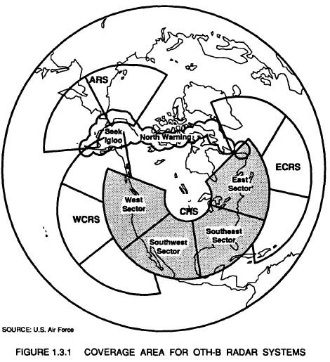
English: Graphic showing the Central Radar System included in East and West coast proposed OTH-B systems |
|---|---|
| Source |
Environmental Impact Statement - Proposed Sites - Central Radar System Over-the-Horizon Backscatter Radar Program (August 1990) https://apps.dtic.mil/sti/pdfs/ADA267644.pdf |
| Date |
1990-08-01 |
| Author |
U.S. Air Force |
| Permission (Reusing this file) |
See below.
|
Licensing
| This file is in the public domain, because (no reason given!)
Please verify that the reason given above is valid! Note: if there is a specific licence tag for the reason supplied here, please use it. |
File history
Click on a date/time to view the file as it appeared at that time.
| Date/Time | Thumbnail | Dimensions | User | Comment | |
|---|---|---|---|---|---|
| current | 18:15, 7 December 2023 | | 470 × 515 (64 KB) | Isidore (talk | contribs) | =={{int:filedesc}}== {{Information |description={{en|1=Graphic showing the Central Radar System included in East and West coast proposed OTH-B systems}} |date=1990-08-01 |source=Environmental Impact Statement - Proposed Sites - Central Radar System Over-the-Horizon Backscatter Radar Program (August 1990) https://apps.dtic.mil/sti/pdfs/ADA267644.pdf |author=U.S. Air Force |permission= |other versions= }} |
You cannot overwrite this file.
File usage
The following page uses this file: